Message: Return type of CI_Session_null_driver::open($save_path, $name) should either be compatible with SessionHandlerInterface::open(string $path, string $name): bool, or the #[\ReturnTypeWillChange] attribute should be used to temporarily suppress the notice
Message: Return type of CI_Session_null_driver::close() should either be compatible with SessionHandlerInterface::close(): bool, or the #[\ReturnTypeWillChange] attribute should be used to temporarily suppress the notice
Message: Return type of CI_Session_null_driver::read($session_id) should either be compatible with SessionHandlerInterface::read(string $id): string|false, or the #[\ReturnTypeWillChange] attribute should be used to temporarily suppress the notice
Message: Return type of CI_Session_null_driver::write($session_id, $session_data) should either be compatible with SessionHandlerInterface::write(string $id, string $data): bool, or the #[\ReturnTypeWillChange] attribute should be used to temporarily suppress the notice
Message: Return type of CI_Session_null_driver::destroy($session_id) should either be compatible with SessionHandlerInterface::destroy(string $id): bool, or the #[\ReturnTypeWillChange] attribute should be used to temporarily suppress the notice
Message: Return type of CI_Session_null_driver::gc($maxlifetime) should either be compatible with SessionHandlerInterface::gc(int $max_lifetime): int|false, or the #[\ReturnTypeWillChange] attribute should be used to temporarily suppress the notice
NRIPage | Articles | Severe Thunderstorm Issued for North Texas: Hail, Wind, and Low Tornado Risk | Get Health & Wellness Tips. Find tips on fitness, mental health, nutrition, and self-care - NRI Page
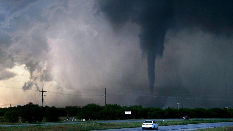
The National Weather Service has issued a Severe Thunderstorm Watch for most of North Texas and parts of Central Texas until 8:00 a.m. this morning. A strong system along a warm front is bringing the potential for very large hail, damaging winds, and a low-end tornado risk in areas close to the front.
What to Expect:
Hail: While egg-sized hail is possible in isolated areas, most locations will see smaller hail or no hail at all.
Wind: Gusts may reach up to 60 miles per hour, capable of causing localized damage.
Tornadoes: The risk is very low, mainly confined to spots right along the warm front.
Timeline Based on Location:
Western DFW Metroplex: Peak storm activity from 2 a.m. to 8 a.m.
Eastern DFW Metroplex: Higher chances from 4 a.m. to 10 a.m.
South/Southeast of DFW: Likely out of the path of the most intense storms.
Additional Weather Notes:
Cooler air and northern winds will dominate the day after storms clear.
Patchy rain is possible west and northwest of DFW during the afternoon/evening.
Sunday will be dry but chilly, with wind chills in the 30s early on and highs stuck in the 50s, well below the seasonal average of 75°F.